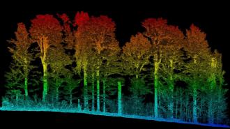
A laser aboard the International Space Station has been used to create a near-global 3D map of the world’s forests, helping scientists estimate the amount of carbon-storing biomass in a given area.
The challenge: Trees pull carbon from the atmosphere and store it in their branches, leaves, and other parts. If the tree is cut down, burned, rots, or otherwise dies, that carbon is then released back into the atmosphere.
Accurate estimates of Earth’s living plant matter (“biomass”) could help with conservation and climate change. They could let us know how much carbon was released after a particular forest fire or clearcutting, for example.
But obtaining accurate numbers has been a challenge — depending on the density of the vegetation, equal-sized forests could be storing very different amounts of carbon.
The new map estimates the amount of vegetation in any given square kilometer.
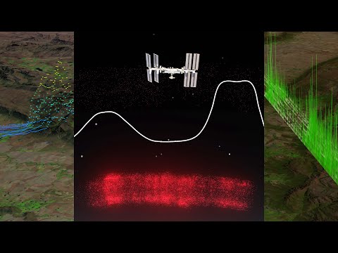
Space lasers: In 2019, an instrument called the Global Ecosystem Dynamics Investigation (GEDI) began firing three lasers at the Earth from the ISS and recording how long it took each pulse to return to the ISS.
Combined with data from air- and ground-based lidar, researchers have now created a near-global biomass map. This map estimates the amount of vegetation in any given square kilometer, along with how confident the number is.
“Now we have the means to provide an estimate of aboveground biomass with known uncertainty that can be used to support climate reporting and a broad range of applications,” said John Armston, GEDI’s lead for validation and calibration.
Looking ahead: The GEDI data is freely available through NASA’s Earthdata Cloud website, and the researchers envision it being used to monitor carbon offset projects, plan new forests, and more.
Even better biomass estimates from GEDI are likely on the way, too. GEDI’s mission has been extended through 2023, and because the ISS recently adopted a slightly lower orbit, the instrument should be able to fill in some gaps in its data and provide more uniform coverage of Earth’s forests.
We’d love to hear from you! If you have a comment about this article or if you have a tip for a future Freethink story, please email us at tips@freethink.com.