A search and rescue operation at sea comes down to one thing: time.
As people spend more time in the water, their chance of survival plummets. And rescuers face immense challenges — the weather, the surface conditions, the currents, the sheer enormity of the sea — as well as the clock.
Modern search and rescue operations can use complex ocean models and weather forecasting data to try to predict where people and objects will drift in the ocean.
But according to the Swiss Federal Institute of Technology in Zurich (ETH Zurich), those standard algorithms become less useful in coastal search and rescue operations, as mercurial waters near the shore and incomplete datasets mean that algorithms often can’t predict where drifting survivors will end up.
That could mean the difference between life and death.
Now, a team led by ETH professor of nonlinear dynamics George Haller is looking to save lives with a new model for search and rescue missions in those chaotic coastal waters.
Using mathematical tools developed for “dynamical systems theory” — i.e., teasing out the behavior of complex, shifting systems, like the ocean — and better data, their algorithm — published in Nature Communications — predicts where people and objects will drift closer to the shore.
The math revealed to Heller’s team that floating objects off the coast gather along certain curves, dubbed “TRansient Attracting Profiles” (TRAPs). TRAPs are hidden from plain sight, but they cannot hide from math — and the ETH algorithm can identify and track them in real time.
That real time ability is absolutely crucial for search and rescue and emergency response models.
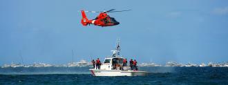
Working with MIT, the Woods Hole Oceanographic Institution, and the U.S. Coast Guard, EHT put their algorithm to the test in the waters off Martha’s Vineyard.
Using the same real time data available to the Coast Guard, the EHT algorithm soon identified the TRAPs of the Massachusetts coast. Buoys and manikins dropped into the Atlantic quickly congregated on the snaking lines.
It’s a promising test run for a tool which may improve search and rescue operations in the near future.
“Our results are rapidly obtained, easy to interpret, and cheap to implement,” Mattia Serra told ETH News. A Harvard postdoc, Serra received his PhD at EHT and is first author on the paper.
Next up is testing the model in other locations. “Our hope is that this method will become a standard part of the toolkit of coast guards everywhere,” Haller told ETH News.
The team also believes their new algorithm has the potential to aid in search and rescue missions on an ecological scale: it may be able to help predict the path of oil spills.
We’d love to hear from you! If you have a comment about this article or if you have a tip for a future Freethink story, please email us at [email protected]