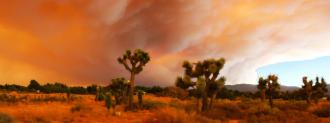
This year, fires have already destroyed entire towns and millions of acres of land in California and other West Coast states — and wildfire season is far from over.
Emergency responders need to be able to track wildfires to effectively combat them, but that’s easier said than done. A slight change in wind direction can set a fire on a new path, and heavy smoke can make it hard to see the exact location of an active fire.
For decades, it was up to human lookouts to track wildfires — from their positions in trees and on mountains, they’d scour forests for smoke — but now, satellites and high-tech cameras are taking over, helping firefighters monitor the blazes more effectively.
NASA’s Contribution
Scientists at NASA are using satellite instruments that view the surface of the Earth in visible, near-infrared, and thermal-infrared wavelengths to track smoke and wildfires in California.
They’re also conducting flyovers of the affected regions with a jet that has special instruments fixed to its underside, which assess wildfire damage and see through smoke to spot fires.
NASA is making all of this data available to the California National Guard, Federal Emergency Management Agency, and other groups working on the ground to help them track wildfires.
A New Google Feature
Google, meanwhile, has launched a new feature that uses satellite data to map the boundaries of active fires — all so everyone can track wildfires in California and know what areas they need to avoid.
“(The National Oceanic and Atmospheric Administration) provides imagery that basically says, ‘We think the pixels in this image are on fire right now,'” Ryan Galleher, engineering program manager in Google’s Search and Crisis Response division, told WIRED.
“They’re using their own fire detection algorithm that runs every five minutes, 24/7,” he continued. “We ingest that data, we run our own fire delineation algorithm against that to sort of draw a boundary around those hot pixels as the fire grows out.”
Academic Assistance
Three universities — the University of Nevada, Reno, University of California San Diego, and the University of Oregon — have teamed up on another tech initiative to track wildfires: AlertWildfire.org.
The earlier you can spot a fire, the earlier you can take suppression action.
Scott Strenfel
This project uses images from hundreds of cameras — some on satellites, some on mountaintops — to create interactive maps of wildfires’ locations. Authorities, such as firefighting commanders, can even rotate or zoom individual cameras to get a better view of a fire.
“We can use this information (from Alert Wildfire) to understand where fires are spreading, where they’re most active and to get rapid alerts for wildfires,” Scott Strenfel, manager of meteorology and fire science at PG&E, told Government Technology.
“It’s pretty exciting with all this technology coming together,” he continued. “The earlier you can spot a fire, the earlier you can take suppression action.”
We’d love to hear from you! If you have a comment about this article or if you have a tip for a future Freethink story, please email us at [email protected].